| Modelling Soil Water Quality Using Wet Areas Maps for Wetlands in New Brunswick and Alberta | |
|---|---|
 |
Dissolved oxygen varies with the extent of atmosphere-soil exchange and soil biological activity. As oxygen is depleted from soil water, redox potential lowers, so less energy is available for organism growth. pH affects the amount of nutrient cations available for plant use and the solubility of toxins such as aluminum and manganese.The objective of this project is to:
i) investigate the relationship between soil water quality and wet areas mapping attributes at two ecozones in Canada ii) use the relationships developed to predict water quality across the landscape. |
| Alberta’s new wet areas mapping initiative: a cost-effective approach to facilitate stewardship | |
 |
Alberta has been working with researchers at the University of New Brunswick since 2004 to develop and test the effectiveness of a depth-to-water table mapping tool. This initiative spans some 22 million hectares from the province’s foothillsto the boreal region. Spatially explicit datasets are used to predict the location of small water bodies such as intermittentsand wet, saturated soils which are currently not known to resource planners but yet are sensitive to disturbance. Datasets also identify the locations of dry, drought prone areas where limited soil moisture may limit forest productivity. Significant efforts are underway to explore this new planning approach within the forestry, parks, and energy sectors. THis is further complemented by research dealing with access management, silviculture, growth and yield, biodiversity, reclamation, recreational trail and road routing, and emergency spill management. Approximately 14 million hectares of lands have been mapped thus far. |
| Wet-areas map: Beauvais Lake Provincial Park, Alberta | |
 |
This poster presents an overlay of the 0-1m cartographic depth-to-water feature overlain on the bare-ground DEM, with the optical surface image draped over this DEM. Viewing the park from this perspective allows park managers and park stakeholders to take inventory of flow channels and wet areas, in relation to: habitat and conservation management, recreational access and related developments, as well as trail design and layout. |
| Examining and further developing predictive soil moisture models based on high resolution DEM datasets | |
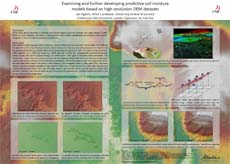 |
THis poster informs about the general process of generating LiDAR-based DEMs, and some of the issues encountered when turning these DEMs into reliable flow channel, wet areas and cartographic depth-to-water maps. Allowing the numerical flow accumulation process to continue automatically across roads on account of culvert placements and other structures underneath the road surface is one of these issues. |
