
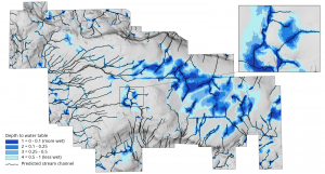
 High resolution inventory solution (HRIS) developed through Tesera is being used to maximize the return on investments on timber and non-timber management properties. Tesera integrated the depth-to-water map produced by the Forest Watershed Research Centre, which helps to outline riparian buffers using stream, wetland, lake, and river datasets.
To see more about this project visit: Maximize Return on Investments using High Resolution Data in Forest Planning – Part 1.