- PhD Defense – Shane Furzeby wp_watershedThe Forest Watershed Research Centre is proud to announced the successful PhD defense of Dr. Shane Furze. His thesis “A High Resolution Digital Soil Mapping Framework for New Brunswick, Canada” presents an approach to digital soil mapping of soil properties for …
- FWRC to Receive Canadian Forest Management Group Achievement Awardby wp_watershedThe UNB Forest Watershed Research Centre has been selected by the Canadian Institute of Forestry as the 2017 recipient of the Canadian Forest Management Group Achievement Award. This Award recognizes the outstanding achievements by teams or groups of managers, researchers, and scientists …
Read more “FWRC to Receive Canadian Forest Management Group Achievement Award”
- Alberta Wet-Areas Mapping Initiative: Ecosystem-based research into boreal forest management: EMEND Symposium 2017 Report (Edmonton, June 6-8, 2017)by wp_watershedOn June 6 and June 8, 2017, a mix of foresters, landscape planners, government scientists, community members, and students gathered to hear current and former graduate students describe their work at the EMEND research site. The presentations and discussions were part …
- Predicted Streams and Depth to Water Table Mapping for the UBC Alex Fraser Research Forestby wp_watershedHigh resolution inventory solution (HRIS) developed through Tesera is being used to maximize the return on investments on timber and non-timber management properties. Tesera integrated the depth-to-water map produced by the Forest Watershed Research Centre, which helps to outline riparian buffers …
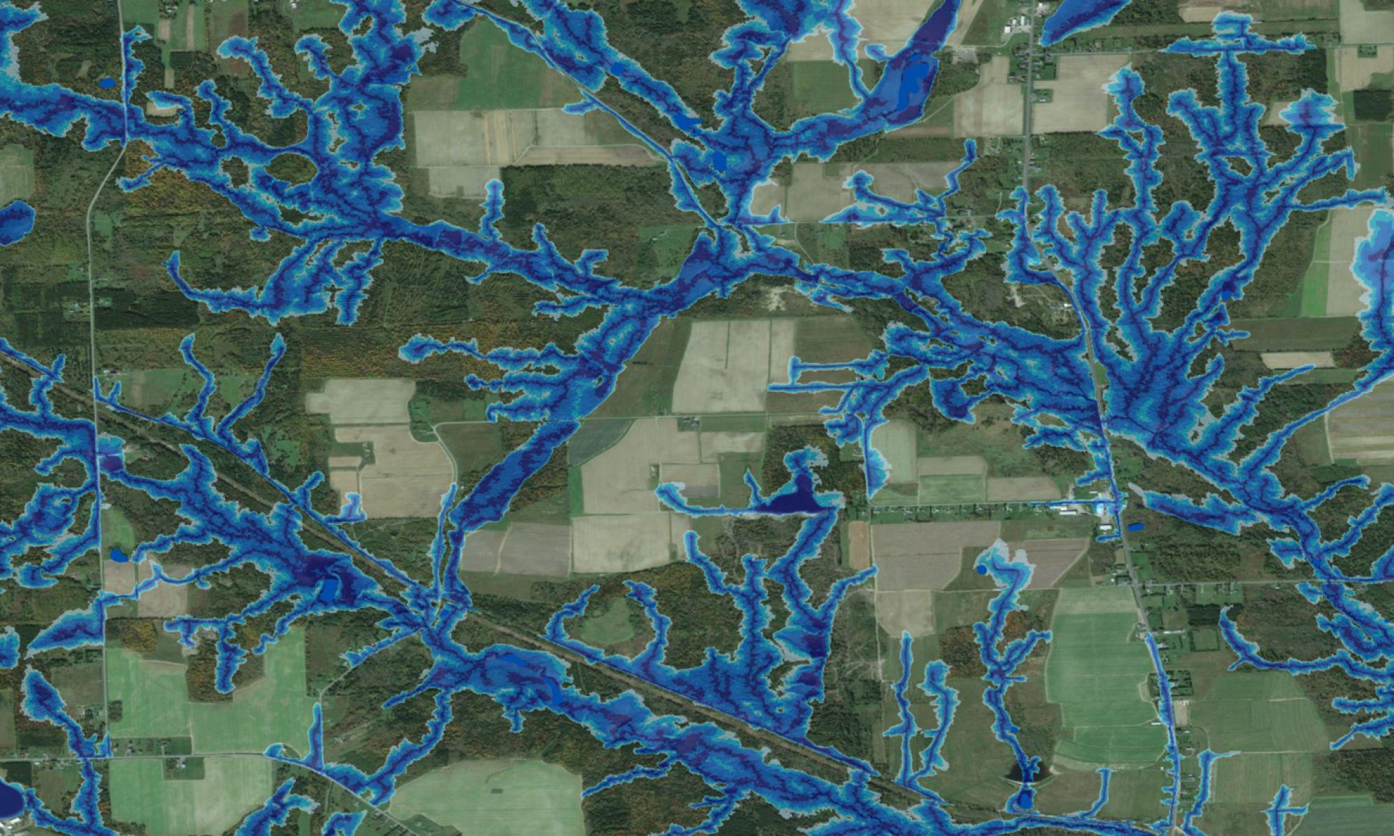
- Drone Captured Images of UNB Campusby wp_watershedForest Watershed Research Centre (March 2017) is further advancing its flow-channel and wet-areas mapping initiative WAM) using “PhoDAR” (Photogrammetric Detection and Ranging) technology. The aim is to model and map flow channels and wet areas at the 1 to 10 cm …
- Tales from the San Diego User Conferenceby wp_watershedA blog post was published on Esri Canada’s website highlighting 2016 Esri Young Scholar Marie-France Jones. It is an interview that explains Marie-France’s work and experience at the Esri San Diego user conference. You can read the interview here: http://esri.ca/en/blog/tales-san-diego-uc-esri-young-scholars-experience.
- An Esri Young Scholar’s Take On the Esri User Conference Experienceby wp_watershedA blog post was published on Esri Canada’s website highlighting 2016 Esri Young Scholar Marie-France Jones. It is an interview that explains Marie-France’s work and experience at the Esri San Diego user conference. You can read the interview here: http://esri.ca/en/blog/esri-young-scholar’s-take-esri-user-conference-experience
- Marie-France Recipient of Esri Young Scholar Award 2016by wp_watershedMarie-France Jones was recognized as Canada’s 2016 Esri Young Scholar Award winner. She was the top candidate in a PhD program. The award recognizes exemplary work in geospatial science. Link to the Esri award announcement. Marie-France is a PhD candidate in …
Read more “Marie-France Recipient of Esri Young Scholar Award 2016”
- Towards the Goal of Environmental Excellence: Alberta’s Wet Areas Mapping Initiative at Year Tenby wp_watershedAlberta’s wet areas mapping initiative was initiated in 2005 and has made positive contributions to land and forest management. During this ten year time period, the wet areas mapping model has undergone a significant transformation to address complex challenges of mapping …
- Flood Risk Modeling and Ecosystem-based Adaptation Round Table: Moncton, Oct. 26, 2015by wp_watershedThe Forest Watershed Research Centre provided a quick overview of its flood extent mapping initiative by way of a short presentation, entitled “Mapping inland and coastal flooding: streams, rivers, lakes”. Meeting details: http://www.nbse.ca/planning/meetings/rsc7-other-meeting-2015-10-26/ [wpdevart_youtube]Utuzw3Heqvg[/wpdevart_youtube]
- Mina Nasr PhD Thesis Defendedby wp_watershedMina Nasr successfully defended her PhD thesis entitled: GEOSPATIAL ANALYSIS OF TOTAL MERCURY CONCENTRATIONS IN STREAM AND LAKE SEDIMENTS ACROSS CANADA. Her thesis was considered “monumental” by the examination committee in terms of scope and detail. Parts of the thesis have …
- Tales from the San Diego User Conferenceby wp_watershedA blog post was published on Esri Canada’s website highlighting 2015 Esri Young Scholar Shane Furze. It is an interview that explains Shane’s work and experience at the Esri San Diego user conference. You can read the interview here: http://esri.ca/en/blog/tales-san-diego-uc-esri-young-scholars-experience.
- Shane Furze Recipient of Esri Young Scholar Award 2015by wp_watershedShane Furze was recognized as Canada’s 2015 Esri Young Scholar Award winner. He was the top candidate in a PhD program. The award recognizes exemplary work in geospatial science. Link to the Esri award announcement. Shane is a PhD candidate in …
Read more “Shane Furze Recipient of Esri Young Scholar Award 2015”
- How much water: When? Where?by wp_watershedThe Forest Watershed Research Centre was featured in Issue 14 of Pan European Networks, a magazine with a focus on Science & Technology (Materials Wealth). To view the article click here.
- Depth-to-Water vs TWIby wp_watershedThis presentation details how height increments of spruce plantations vary in relation to two rasterized LiDAR-DEM derived indicators of soil wetness / drainage, i.e., the cartographic Depth-to-Water index DTW, referring to the elevational rise away from nearest streams and other surface …
- Beyond the Watershedby wp_watershedThe Forest Watershed Research Centre was featured in Issue 161 of International Innovation, a magazine with a focus on science, research and technology. To view the article click here.
- Shortcuts – Right methods can halve ground damageby wp_watershedThe LiDAR-based depth-to-water maps produced by the Watershed Center was featured in the Skogforsk 2014 edition of ShortCuts, a quarterly report that showcases the latest forest research news from Sweden.
- A Technical Overview of Alberta’s Wet Areas Mapping Datasetsby wp_watershedJae Ogilvie provides a definitive description of Alberta’s wet area mapping research and the development and opportunities from Canada’s largest wet area mapping dataset. This series of videos cover an hour long lecture, given by Jae Ogilvie, Friday, April 11, 2014 …
Read more “A Technical Overview of Alberta’s Wet Areas Mapping Datasets”
- 22nd Annual Emerald Awards Ceremony Onlineby wp_watershedThe 22nd Annual Emerald Awards Ceremony celebrates environmental excellence in Alberta. The Government of Alberta received the award in 2013 for the Development for Alberta’s Wet Areas Mapping Initiative through the Forest Research Watershed Center. Watch the videos of the ceremony by …
- Climate change rains – CBC Interviewby wp_watershedSome people in Grand Lake believe recent rain and flooding is a sign of more dramatic and permanent changes to the climate. CBC Interview Link
- Wet-Areas-Mapping reaching the pipeline industryby wp_watershedThe word about wet-areas mapping has reached the pipeline industry, as evident from the following news article. Learning from LiDAR – Wet Areas Mapping program giving industry a better view of the landscape
- 2013 Recipient of the Emerald Awardsby wp_watershedEdmunton, June 6, 2013. Emeral Awards. The Alberta Department of Environment and Sustainable Resource Development was recognized for its Wet Areas Mapping Initiative, done through collaboration with the Forest Watershed Research Centre of the Faculty of Forestry and Environmental Management at UNB.
- ShortCuts – Environmental Impacts of Forwarding, 2013by wp_watershedThe LiDAR-based depth-to-water maps produced by the Watershed Center was featured in the Skogforsk 2013 (1) edition of ShortCuts, a quarterly report that showcases the latest forest research news from Sweden.
- Climate Change Adaptation: Evaluating hydrological risks using LIDAR mappingby wp_watershedMay 1, 2013 at the UNB Wu Conference Center, Fredericton, NB A summary dealing with hydrology risks in New Brunswick and how to utilize LiDAR mapping to delineate areas of high risk.
- The 22nd Annual Emerald Awards, June 6, 2013, Edmontonby wp_watershedAmong the finalists (Government Institutions): Alberta Department of Environment and Sustainable Resource Development (ESRD) Alberta’s ESRD Department actively pursues innovative solutions to balance economic, environmental and social concerns. In part, doing this places emphasis on conserving aquatic habitats and sensitive lands. …
Read more “The 22nd Annual Emerald Awards, June 6, 2013, Edmonton”
- New Brunswick Climate Change Adaptation Project Profilesby wp_watershedUsing LiDAR generated point cloud data, the Forest Watershed Research Center is assisting the province of New Brunswick in mapping and classifying potential hydrological risks (especially flooding and erosion) inland and along the coasts. The project will provide provincial and municipal authorities with a …
Read more “New Brunswick Climate Change Adaptation Project Profiles”
- Alberta’s Wet Areas Mapping Initiative: Innovation supporting continuous improvement in environmental performanceby wp_watershedAlberta Environment and Sustainable Resource Development, in close partnership with the University of New Brunswick, has completed the development of wet area datasets for 14 million hectares along its Foothills to Boreal Region. These datasets, done at 1 meter resolution using …
- Flood Risk & Depth to Water Mappingby wp_watershedPresentated at: Preparing for Climate 2100 – Tools and strategies for NB communities. November 14th to 16th, 2012, Fredericton Convention Centre. The Forest Watershed Research Centre presented the current state of LiDAR-based wet-areas mapping in New Brunswick, in a series of three 30 …
- Wet-areas Mapping in Northern Alberta – Field Tour of Slave Lake, Albertaby wp_watershedField Tour Guide Slave Lake, Alberta on September 25th 2012
- FP Innovations August 2012by wp_watershedEnhanced prediction of soil disturbance in forest harvest operations Research at FP Innovations furthers the understanding and protection of forest soils through activities focused on real-time tracking of harvest machines and related machine-soil interactions. These activities contribute to developing a soil …
- Video coverage of LiDAR relevant to wet-areas mapping process and application in Albertaby wp_watershedMembers from the Forest Watershed Center participated in the March LiDAR workshop titled “Building a sustainable Alberta through the application of LiDAR technologies” held earlier in Calgary this year, March 1-2, 2012. Click here to see the videos of the presentations relevant to …
Read more “Video coverage of LiDAR relevant to wet-areas mapping process and application in Alberta”
- Video coverage on Lidar Newsby wp_watershed[We found] an impressive video from the wet-areas initiative at the Forest Watershed Research Centre of the University of New Brunswick. The animation was done by the Targetlock studio in Fredericton, New Brunswick. The video was created using full-resolution LiDAR point cloud elevations and …
- LiDAR workshop 2012: Building a sustainable Alberta through the application of LiDAR technologiesby wp_watershed– Greening Alberta’s Energy Sector: Lessons leaned from the Rainbow Pipeline Spill of 2011 (Jae Ogilvie, Barry White, Paul A. Arp) – Application of LiDAR within government of Alberta: ASRD; Alberta Culture and Community Spirit; Alberta Tourism, Parks and Recreation; Alberta Geological …
- ASTECH Gala Eventby wp_watershedAlberta Advanced Education and Technology nominated the Forest Watershed Research Center’s wet areas mapping team Barry White, Jae Ogilvie and Paul Arp as ASTECHHonourees in the category of Outstanding Achievement in Environmental Technology and Innovation, sponsored by Agrium Inc.
- Making Better Business Decisions Using Enhanced Forest Inventoriesby wp_watershedby Steve D’Eon Viewpoints BC Forest Professional / May-June 2011 LiDAR also provides extremely accurate terrain mapping for optimizing road location, cut block layout and wet area mapping. The Wet Areas Mapping Initiative in Alberta has imported a tool developed at the …
Read more “Making Better Business Decisions Using Enhanced Forest Inventories”
- The Edge: Forest Innovation for Western Canada’s Forest Landscapes, People and Products (March 2011)by wp_watershedLiDAR-based vegetation type mapping in Alberta – by Paul Arp, Doug Hiltz and Barry White and Innovation spurs stewardship solutions – by Paul Arp, David Campbell and Barry White
- Predictive Wet Areas map in New Brunswickby wp_watershedCBC Radio Interviews with Dr. Arp on the issues surrounding the predictive wet areas map in New Brunswick. Fredericton Interview (March 25, 2011 at 7:41am) Moncton Interview (March 25, 2011 at 7:20am) New Brunswick Regional Adaptation Collaborative Project Newsletter (English / French) – …
- Wet Area Mapping (WAM) development at the University of New Brunswickby wp_watershedby Barb Scott, University of New Brunswick
- High-resolution flow-channel and wet-areas maps: a tool for better forest operations planningby wp_watershedby Paul A. Arp. FMN Research Note # 55
- SFMN Network Workshopsby wp_watershedAlberta’s New Wet Areas Mapping Initiative. Wet Areas Mapping Program Overview [PDF] Barry White, Alberta Sustainable Resource Development. Wet Areas Mapping Principles and Application [PDF] Dr. Paul Arp, University of New Brunswick. Wet Areas: Technical Issues Related to Data use and …
- Wet Areas Mapping and Flow Accumulation Channelsby wp_watershedWet-area maps for down-loading. Department of Natural Resources, Nova Scotia (November 2009).
- Four-stop road show introduces managers to innovative mapping softwareby wp_watershedAFEX – the Alberta Forest Extension Network – The Edge: Forest Innovation for Western Canada’s Forest Landscapes, People and Products (November 2009).
- Alberta’s new wet-areas mapping initiativeby wp_watershedby Kristen Foreman, B.I.T – BIOS. Alberta Society of Professional Biologists (Winter 2009).
- Mapping software helps take the surprise out of land managementby wp_watershedby David Holehouse – The Edge: Forest Innovation for Western Canada’s Forest Landscapes, People and Products (November 2009).
- Restigouche River Watershed Council Inc.by wp_watershedConsidering water-table depth in forest management: towards better forest management planning and operations practices, by Gaetan Pelletier, J.D. Irving.
- Partnerships key to sustainable forest managementby wp_watershedby Gavin Mealing. Media West Communications Inc. (October 2008).
- Harvesting on Wet Ground Workshopby wp_watershedSoil Survey Information + Wet Areas Mapping, by Kevin Keys, Department of Natural Resources, Nova Scotia.
- Wet areas mapping project uncovers benefitsby wp_watershedby David Holehouse – The Edge: Forest Innovation for Western Canada’s Forest Landscapes, People and Products (June 2008).
- SFMN Biomass Workshopby wp_watershedSynopsis of on-going Canadian research on biomass harvesting and site productivity, by Brian Titus, Shannon Berch, Dave Morris, Rob Fleming, Paul Hazlett, David Pare, and Paul Arp. The scientific foundation for sustainable forest biomass harvesting guidelines and policy. SFMN Biomass Workshop. Toronto. …
- Modeling and Mapping Sustainable Biomassby wp_watershedModeling and Mapping Sustainable Biomass Yields and Nutrient Expectations, with Forest Policy and Forest Operation Perspectives, by Paul A. Arp, Mark Castonguay, and Jae Ogilvie, Faculty of Forestry & Environmental Management, University of New Brunswick.From the 2008 FPS Eastern Canadian Section Spring …
- Alberta’s Wet Areas Mapping Initiative: A Cost Effective and Innovative Approach to Facilitate Sustainable Developmentby wp_watershedby J. B. White, P. Arp and J. Ogilvie. Peatland Ecosystem Analysis and Training NETwork Conference: Reclamation and Restoration of Boreal Peatland and Forest Ecosystems: Toward a Sustainable Future. Edmonton, Canada. March 25-27, 2010
- SFMN Network Workshopsby wp_watershedSFMN wet-areas mapping project update: towards better forest management, planning and operations practices – Maritime Knowledge Exchange Workshop
- CFRU Wet Areas Mapping Projectby wp_watershedby Will Mitchell. Cooperator Workshops: Research, Results, and the Resource (Orono, ME).