tOOLS
The Forest Water Research Centre prides itself on innovative partner-based research. Various user tools have been made to help further industry as well as academic research. The following are a few tools that are being used for current research. If you have an interest in a particular tool, please contact us. We would be happy to collaborate on future projects.
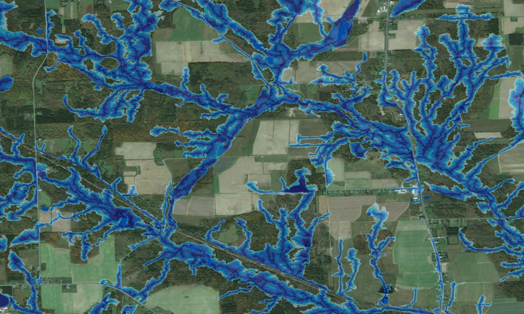
Wet Areas Mapping (WAM) is based on determining flow channels, wet and dry areas, and the cartographic depth-to-water index (DTW) from bare-ground digital elevation models (DEMs). This process is further refined to ensure that the digitally derived flow channels conform to all already mapped open water features such as streams rivers, lakes and shorelines.
*Currently available to the public for a free trial. It is easily downloadable and comes with an extensive user manual.
The Trail Routing, Analysis, Investigation, and Layout (TRAIL) enables users to develop and evaluate alternate road and trail locations from one point to another across the landscape.
The Forest Hydrology Model (ForHym) was developed as a means to quantify thermal and hydrological conditions and flows on a multi-year daily basis for forest sites and watersheds. The model uses daily precipitation (snowfall and rain, in cm) and temperature along with soil and catchment characteristics (latitude, altitude, slope, area, soil depth, etc…) to predict various aspects of pre- and post-harvest forest hydrology and nutrient cycling in a non-spatial trickle-down mode.
Hydrological risk mapping deals with locating and delineating areas where there would be potential risks in terms of flooding, wash-out, erosion, mudslides and avalanches. Planners working with industry, municipalities and developers are aware of these risks but do require good mapping tools that reveal these risks in a fairly reliable fashion and in sufficient detail. Our approach to hydrological risk mapping involves deriving a number of features from local digital elevation models (DEMs ) and related geomatic themes referring to flow direction, flow accumulation, flow channels, slope gradients, cartographic depth to water (DTW), depth-in-sinks, catchment and sub-catchment areas,and recharge-versus-discharge areas including seepage locations.
Trafficability
Cross-terrain off-road trafficibility is one of the main use of the DEM-derived flow channel, wet-areas and cartographic depth-to-water maps. Current applications involve projecting machine- and operation-specific rutting depths, as affected by weather and related ground conditions as these vary from day to day and across seasons. The map on the right shows a DTW-revised raster indicating trafficability from red-brown (very poor) to yellow (fair) to OK (green). Other trafficability constraints also need to be considered, such as slope, demarcations of environmental and cultural sensitivities, and existing road networks.
The cartographic depth-to-water index permits mapping vegetation communities by moisture regime requirements at high resolution. In part, this includes an automated process for delineating upland wetland borders.
Work at the Forest Watershed Research Centre includes learning how soil type, processes and properties vary across forested landscapes. The wet-areas modellign and mapping approach has been very helpful in this regard, because small-scale variations in soil type are closely knitted to local water flow and retention patterns as revealed fairly reliably and in great detail by the metric and cartographically defined depth-to-water index (DTW). This index emulates the geospatial distribution of soil drainage conditions quite well from very poor to excessive,and is also a good variable for quantifying geospatially distributed processes such as soil-based denitrification. The entries within this section document some of the results achieved so far.
A key for understanding how mercury moves from the atmosphere into fish and wildlife is to know where Hg accumulates in the landscape. Basically, forest canopies are very effective scavengers of atmospheric Hg, whether Hg is in gaseous, water-dissolved, or particulate form. Hg, once captured at canopy level, is transferred to the forest floor, gradually and seasonally, through litter fall. Depending on local soil drainage, part of this Hg becomes methylated, and is rendered toxic through the trophic process of bio-accumulation. Some of the Hg stored in the forest floor is recycled through vegetative uptake, with mycelial Hg ubtake and subsequent transfer to fungal fruiting bodies (mushrooms) providing a pathway for terrestrial Hg bio-accumulation.
With the rising economic and environmental costs associated with fossil fuel extractions and use, and related threats to ecosystems due to rising CO2 levels in the atmosphere and concurrent climate change, alternative energy sources that are sustainable as well need to be realized. Within the forestry sector, harvesting forest biomass is one of these alternatives. The long-term sustainability of forest sites and watersheds due to biomass harvesting, however, depends greatly on site-specific factors such as soil nutrient availability, current stand conditions (canopy height and tree composition), climate, hydrology and underlying geology and soil quality.
From time to time, we get requests to provide individuals or organizations outside Canada with high-resolution flow-channel, wet-area and cartographic depth-to-water maps. In this way, we produced maps for all of Maine, Vermont, Hawaii, and other locations in the USA. Lately, we have also derived DTW index maps for all of Belize, Haiti, and parts in Romania/ Bulgaria, Slovenia, Uruguay, Germany and Malaysia. These efforts are generally based on local DEM data, or – if such are not available – on downloadable NASA STRM or ASTER DEM data.
Check out the links below!