• Home
  • Our Team
  • Education
    • Educational Outreach
    • Undergraduate Opportunities
    • Postgraduate Opportunities
  • Research
    • Tools
      • WAM- Wet Areas Mapping
      • TRAIL- Trail Routing, Analysis, Investigation, and Layout
      • ForHyM- Forest Hydrology Model
    • Hydro-Risk Mapping
      • New Brunswick
        • Acadian Research Forest
        • Fredericton
      • Alberta
      • WAM Initiative Seminar
      • Moose Cree First Nation Workshop
      • SFMN Conference
    • Trafficability
    • Vegetation Habitat Modelling
    • Soils
    • Mercury
    • Biomass
    • International Projects
      • Belize
      • Germany
      • Haiti
        • Jacmel
        • Port-au-Prince
      • Hungary
      • Malawi
      • Mexico
      • Uruguay, Rio Negro
      • United States
        • Hawaii
        • Maine
      • Venezuela
  • Publications
  • News
    • Videos
    • Award-Winning Posters
  • Contact

Recent Posts

  • Tools
  • PhD Defense – Shane Furze
  • FWRC to Receive Canadian Forest Management Group Achievement Award
  • Alberta Wet-Areas Mapping Initiative: Ecosystem-based research into boreal forest management: EMEND Symposium 2017 Report (Edmonton, June 6-8, 2017)
  • Predicted Streams and Depth to Water Table Mapping for the UBC Alex Fraser Research Forest

Recent Comments

No comments to show.

Archives

  • August 2023
  • September 2018
  • October 2017
  • July 2017
  • June 2017
  • March 2017
  • August 2016
  • May 2016
  • March 2016
  • October 2015
  • September 2015
  • June 2015
  • November 2014
  • August 2014
  • April 2014
  • October 2013
  • July 2013
  • June 2013
  • May 2013
  • April 2013
  • February 2013
  • November 2012
  • September 2012
  • August 2012
  • July 2012
  • March 2012
  • October 2011
  • May 2011
  • March 2011
  • February 2011
  • April 2010
  • December 2009
  • November 2009
  • October 2009
  • October 2008
  • June 2008
  • February 2008
  • January 2008
  • March 2007
  • May 2006

Categories

  • News
  • Uncategorized
Skip to content
Forest Watershed Research Centre
  • Home
  • Our Team
  • Education
    • Educational Outreach
    • Undergraduate Opportunities
    • Postgraduate Opportunities
  • Research
    • Tools
      • WAM- Wet Areas Mapping
      • TRAIL- Trail Routing, Analysis, Investigation, and Layout
      • ForHyM- Forest Hydrology Model
    • Hydro-Risk Mapping
      • New Brunswick
        • Acadian Research Forest
        • Fredericton
      • Alberta
      • WAM Initiative Seminar
      • Moose Cree First Nation Workshop
      • SFMN Conference
    • Trafficability
    • Vegetation Habitat Modelling
    • Soils
    • Mercury
    • Biomass
    • International Projects
      • Belize
      • Germany
      • Haiti
        • Jacmel
        • Port-au-Prince
      • Hungary
      • Malawi
      • Mexico
      • Uruguay, Rio Negro
      • United States
        • Hawaii
        • Maine
      • Venezuela
  • Publications
  • News
    • Videos
    • Award-Winning Posters
  • Contact

Flood Hazard Mapping

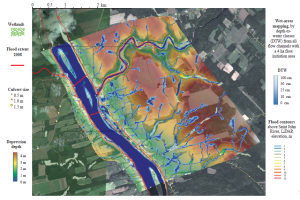
The Atlantic Climate Adaptation Solutions Association was derived to aquire flood hazard mapping for cities across New Brunswick. The following report outlines the mapping initiatives produced for each city (Nackawic, Florenceville, Meductic, Hartland, and Woodstock).

nbwam3

Download PDF

Presentation

Hydrological Risk Mapping for New Brunswick Centered on the Lower Saint John Valley

Powered by WordPress Inspiro WordPress Theme by WPZOOM