
Current Graduate Students

Shirazum Munira, BSc, MScEM
Developing an ArcGIS toolset for automated road-stream breaching for seamless stream channel delineation
Email: shirazum.munira@unb.ca

Liz White, BScEM, MScF
Mapping and modelling tolerant hardwood regime preferences and growth
Email: ewhite5@unb.ca

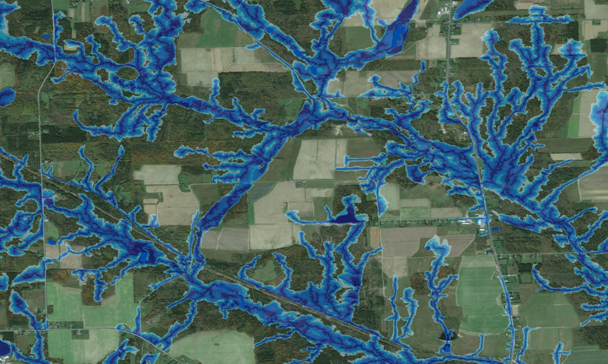
Rachel Tzeckas, BA, MScF
Semi-automated wetland extent mapping at 1m resolution using ArcGIS
Email: rtzeckas@unb.ca

Emily Nicholson, BScF, MScF
LiDAR based forest plantation productivity modelling
Email: enichol2@unb.ca

Ebenezer Asiedu-Agyei, BSc, MScF
Assessing soil moisture regimes using LiDAR derived datasets and statistical modelling techniques
Email: easiedu.agyei@unb.ca

Sharad Sigdel, BSc, MScF
Developing advanced LiDAR based maps to assess and optimize orchard suitability
Email: sharad.sigdel56@unb.ca


Dan Snow, BScF, MScF
Modelling and mapping likely soil rutting occurrences across forested areas
Email: daniel.snow@unb.ca
Past PhD Theses
-
- Marie-France Jones. 2019. Mapping soil trafficability by way of temporal hydrology modeling and spatial wet-areas-mapping.
- Shane Furze. 2018. A high-resolution digital soil mapping framework for New Brunswick, Canada.
- Mina Nasr. 2015. Geospatial analysis of total mercury concentrations in stream and lake sediments across Canada.
- Zhanxue Zhu. 2001. Simulating monthly soil leaching rates using a forest biomass and nutrient cycling model.
- Xinbiao Zhu. 2001. The role of xylem cavitation and shoot and root freezing injuries in yellow birch decline: experiments and model.
- Mohammad Hadi Moayeri. 2000. Mass balanced related sustainability of forest biomass production: concepts and applications.
- Roger James Roy. 1996. Towards an ecological georeferenced framework for forest management planning.
- Fan-Rui Meng. 1994. Sulfur dioxide effects on net photosynthesis and cumulative CO2 fixation in Red Spruce stands.
- Charles Bourque. 1993. Modelling the extent of SO2 plume dispersal from the Grand Laked coal-burning power station.
Past Master’s Theses and Reports
-
- Hannah Green. 2024. Assessing the landscape drivers of cold-water temperatures at tributary confluence plumes: A multi-spatial analysis.
- Nana Agyei Owusu Afriyie. 2023. GIS based modelling for forest road alignments, culvert placements and logging trail delineations.
- Kamille Lemieux. 2022. LiDAR-based potato crop suitability mapping along the upper Saint John River valley in New Brunswick.
- Wei Chen. 2020. Assessing pesticide loading and concentration with assistance of integrated hydrological models in streams of small to medium- sized watersheds.
- Yanyi Li. 2018. Site-specific water quality analysis of sediments and surface waters in Fredericton.
- Jae J. Ogilvie. 2017. Flow-line and wet-areas conformance testing of wetland locations using LiDAR and SRTM elevation data.
- Monique Goguen. 2016. Modelling and mapping distributions of common bryophytes across New Brunswick using a LiDAR-derived depth-to-water index.
- Kyle Chisholm. 2014. Modeling and mapping shallow water properties.
- Amanda Smith. 2014. Wood decomposition and nitrogen mineralization modelling across north and central America.
- Doug Hiltz. 2014. Predictive vegetation type mapping using cartographic depth-to-water, slope, aspect, and elevation.
- Marie-France Jutras. 2012. Modeling stream discharge in forest catchments across Canada: Hydraulic conductivity calibrations.
- Jeanne Moore. 2012. Refining detail of forest site classification for the Fundy Model Forest in New Brunswick.
- David Campbell. 2012. TRAIL: Optimizing trail locations by terrain conditions and other considerations, at high resolution.
- Joshua Noseworthy. 2011. A mass balance, biogeochemical framework for assessing forest biomass harvest sustainability.
- Xinyan Chi. 2008. Hydrogeological assessment of stream water in forested watershed: temperature, dissolved oxygen, pH and electrical conductivity.
- Xiangfei Meng. 2008. Design of GIS based forest road layout and environmental assessment tool.
- Jason Glode. 2008. Analyzing and modeling windthrow along riparian zones in Newfoundland.
- Eric R. Labelle. 2008. Assessing soil disturbances caused by forest machinery.
- Mina Nasr. 2007. Mercury levels in fungal fruiting bodies from interior and coastal forests in the Bay of Fundy region, New Brunswick, Canada.
- Laura Sweeney. 2007. Mercury cycling through finfish aquaculture within the lower Bay of Fundy: possibilities for control in support of the health of coastal communities.
- Catherine Irene Otorowski. 2005. Mercury in gulls of the Bay of Fundy.
- Chengfu Zhang. 2005. Modelling of forest litter decomposition and nitrogen mineralization.
- Matthew Steeves. 2004. Pre- and post-harvest groundwater temperatures, and levels, in upland forest catchments in northern New Brunswick.
- Darren Allen. 2003. Spring dieback of yellow birch in North America: historical examination of weather and frost hardiness.
- F. Craig Fowler. 2003. Modelling watershed responses to agriculture and forestry in the potato belt of North-Western New Brunswick.
- Joseph Pomeroy. 2002. Stream turbidity signatures within the Hayward Brook Watershed Study.
- Brenton William Stanley. 2002. The Hayward Brook Watershed Study: hydrogeochemistry and responses to forest operations.
- Vincent Balland. 2002. Hydrogeologic watershed modeling with special focus on snow accumulation and snowmelt including retention and release of major ions.
- Bradley Case. 2001. Use of the flow accumulation concept in interpreting spatial patterns of select soil properties at two New Brunswick watershed sites.
- Brian Simpson. 2000. Water quality effects of forest operations on fourth, fifth, and sixth order streams.
- Zhanxue Zhu. 1998. Modeling the effects of harvesting on nutrient cycling and long-term site sustainable productivity.
- Shelagh Yanni. 1995. Hydrogeochemical assessment of water in forested watersheds at Kejimkujik National Park: discharge rates, chemical composition, and ion fluxes.
- Kevin Jewett. 1995. Hydrogeochemical observations and simulations for pre- and post-harvest conditions at the Nashwaak Experimental Watershed Project.
- Kevin Keys. 1995. An ion resin disc method for estimating percolation ion fluxes in forest soils.
- Kajetan Tadeusz Mellerowicz. 1989. Elemental contents (Al, Fe, Ca, Mg, K, Mn, P) and field response of two New Brunswick forest soils and of black spruce to simulated acid precipitation.
- Timothy Peter McGrath. 1985. Forest biomass accumulations: A parametric approach.
- Rock Ouimet, 1985. Effects of aluminum speciation on nutrient and aluminum uptake of Black spruce in sand-culture experiments.
- Wietse Lense Meyer. 1984. Organo-metal-phosphate complexation.